Newport, RI
HARBOR WALK NORTH
[ The Point and Goat Island]
[map here]
... History Preserved,
an Island "Repurposed"
|
 |
Newport Harbor
Walk Newport Harbor
Walk South
New Animated and GPS-Based Google Map Instructions [Beta
Test]
Also See: Newport Cliff
Walk and Newport's Ten Mile
Drive |
 Harbor Walk
North provides a two-dimensional view of the colonial harbor area of
Newport. Here's where the tall ships arrived from England and where Newport
merchants re-shipped their cargos throughout the colonies. Most of the today's
main harbor south of the Causeway at that time was too shallow for tall ships,
and eventually was dredged deeper over a hundred years later. Harbor Walk
North provides a two-dimensional view of the colonial harbor area of
Newport. Here's where the tall ships arrived from England and where Newport
merchants re-shipped their cargos throughout the colonies. Most of the today's
main harbor south of the Causeway at that time was too shallow for tall ships,
and eventually was dredged deeper over a hundred years later.
During the War for
Independance in the late 1700s this original "Point" working waterfront was
devastated when British troops chopped up docks for firewood during the winter.
Subsequently this mini village became entirely residential with a large number
of the early colonial homes in addition to larger Victorian homes highlighting
the area. Before the causeway was built in 1962, this was a major Federal
channel into Long Wharf.
All
of this residential Point tranquility is opposite a completely many time
repurposed island bought from the Narragansett Indians in the 1600s. Goat
Island is mostly remembered as an active Navy base which topped out when the
entire island became the torpedo manufacturing center in the 1940s.
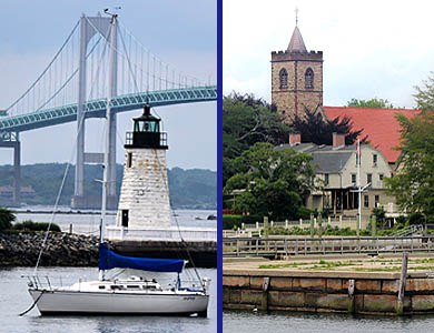
 Today Goat Island provides
spectacular views of the Pell Bridge to the north, Rose Island toward the west,
the East Passage to the southwest. This western seawall abuts a public walk to
the Green Light and provides great spectator area for the active sailboat
racing and practice area right off the breakwater. On the east side south of
the causeway is an ideal photo spot of the main harbor waterfront as the Sun
goes west. Goat Island is privately owned. Today Goat Island provides
spectacular views of the Pell Bridge to the north, Rose Island toward the west,
the East Passage to the southwest. This western seawall abuts a public walk to
the Green Light and provides great spectator area for the active sailboat
racing and practice area right off the breakwater. On the east side south of
the causeway is an ideal photo spot of the main harbor waterfront as the Sun
goes west. Goat Island is privately owned.
The magenta line on Google
map below is just a suggested route to mark your adventure. If there are no
signs telling you to stay away, feel free to explore.
11.  Start Harborwalk North
on Washington St. at Storer Park which was willed by the Storer Family
for a park for mothers and children, and is one of Newport's most popular
waterfront parks. Where its seawall meets the causeway is a favorite spot for
local fishermen. Here also is a rarely seen waterside basketball court. Start Harborwalk North
on Washington St. at Storer Park which was willed by the Storer Family
for a park for mothers and children, and is one of Newport's most popular
waterfront parks. Where its seawall meets the causeway is a favorite spot for
local fishermen. Here also is a rarely seen waterside basketball court.
The park is the start of the
now residential Point Section, as well as the turning point to Goat Island over
the Goat Island Causeway. President George Washington landed at the south end
of this street on one of his visits and citizens named it Washington
St.
The historic "Point"
section was home to boat builders, craftsmen, sea captains, merchants, and
fishermen. They lived and worked closely with the sea and were in daily contact
with the large bustling wharves lining this part of the Newport waterfront over
200 years ago.
 The driftways, originally
access to the wooden docks for tall ships all along this part of the
waterfront, were subsequently used to allow hurricane tides to flood the
streets without damaging the homes. But these ends of streets ensured the
public's right to access to the shoreline. With the help of
Friends of the Waterfront in the
early 1980s, all Point driftways are designated Public Access Rights of Way by
the RI Coastal Resources Management Council: Elm St., Poplar St., Willow St.,
Walnut St., Chestnut St., Cherry St., Pine St., Battery St., VanZandt Ave., and
Cypress St.]. The driftways, originally
access to the wooden docks for tall ships all along this part of the
waterfront, were subsequently used to allow hurricane tides to flood the
streets without damaging the homes. But these ends of streets ensured the
public's right to access to the shoreline. With the help of
Friends of the Waterfront in the
early 1980s, all Point driftways are designated Public Access Rights of Way by
the RI Coastal Resources Management Council: Elm St., Poplar St., Willow St.,
Walnut St., Chestnut St., Cherry St., Pine St., Battery St., VanZandt Ave., and
Cypress St.].
Continue north
along the shore to
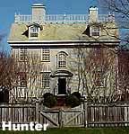
Hunter House,
restored by the Preservation Society, as an example of the finest eighteenth
century colonial architecture
 and furnishings. Its formal
garden overlooks the water and Elm St. Pier. There is a path along the sea
wall. Hunter House resident history illustrates the diversity that occured over
the centuries: Tories, French Navy, diplomats, physicians, and a boarding house
to Catholic nuns. and furnishings. Its formal
garden overlooks the water and Elm St. Pier. There is a path along the sea
wall. Hunter House resident history illustrates the diversity that occured over
the centuries: Tories, French Navy, diplomats, physicians, and a boarding house
to Catholic nuns.
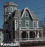
The Sarah
Kendall House across from Hunter House is an eloquent empire Victorian frame
home, built in 1871 for Sarah Kendall, wife of a wealthy shipping merchant.
Just north of Hunter House
is the Elm St. driftway, boat ramp, and pier. While not an "approved" swiming
area, the pier
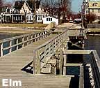 and its earlier versions, have
hosted kids facinated by jumping off the dock's end for centuries. and its earlier versions, have
hosted kids facinated by jumping off the dock's end for centuries.
Walk out to the end of the pier to
look north to the Pell [Newport] Bridge and west to the over 100-year-old
Green Light at the
north end of Goat Island.
 As you walk north from
Storer Park each block offers fine examples of eighteeth and nineteenth century
architecture. As you walk north from
Storer Park each block offers fine examples of eighteeth and nineteenth century
architecture.
While not
all on this waterfront walk the
Newport
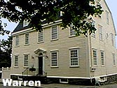
Restoration Foundation has 27 historic homes close by. On the corner of
Poplar and Washington are former Quaker homes. The Captain John
 Warren House (1736), a Georgian
colonial is at 62 Washington St. Warren House (1736), a Georgian
colonial is at 62 Washington St.
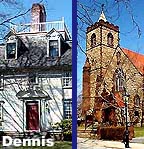
 The Dennis House (1740) is the rectory of
St. John's Church, a gothic style Anglican church. The Dennis House (1740) is the rectory of
St. John's Church, a gothic style Anglican church.
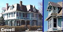
Across the street, a fortune
made during the Civil War built the Sanford-Covell House, its interior and
exterior a fine example of a Victorian summer
house.
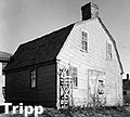 The John Tripp House (1720) was
moved down from Providence on a barge, and is noted for its rare stone end
chimney with an ornamental beehive oven. The John Tripp House (1720) was
moved down from Providence on a barge, and is noted for its rare stone end
chimney with an ornamental beehive oven.
Dyre Carr House ...
1740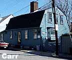 From Granddad Carr's will: "I give
my son Robert my dwelling house and wharf from the corner post that leads into
the well yard upon a straight line to the sea, and to have all the land upon
the straight line from that post adjoining to the house and pasture."
From Granddad Carr's will: "I give
my son Robert my dwelling house and wharf from the corner post that leads into
the well yard upon a straight line to the sea, and to have all the land upon
the straight line from that post adjoining to the house and pasture."
Tripp-Southwick House
1758/1880 combines elements of over two centuries of remodeling.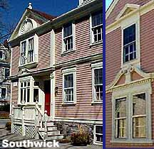
Battery Park (1877) built on the
earthenworks of Fort Greene, provides a scenic place to relax and view
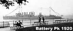 spectacular sunsets over Newport
Bridge. spectacular sunsets over Newport
Bridge.
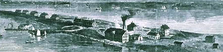
This colonial
battery for the British was an American defense site in the War of 1812. Photo
on left is just after WW1 when U.S. Navy battleships were anchored in the bay.
A few steps down the driftway is Blue Rocks, a favorite swimming place, where
you can see parts of the fort's old
face.
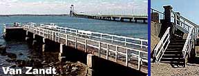 Van Zandt Pier has been a popular place for
fishing and youth swimmers for generations. At low tide the steps allow the
adventurous access to the shore. Van Zandt Pier has been a popular place for
fishing and youth swimmers for generations. At low tide the steps allow the
adventurous access to the shore.
 The Bridge crosses this fine
friendly neighborhood which borders Navy land to the north. But the Navy no
longer needs the property and it should be available soon for non military use.
Before the Bridge was built, Washington St. extended to the Navy base. Over the
next five years decisions will be made as to how far north the Newport Harbor
Walks will reach. The Bridge crosses this fine
friendly neighborhood which borders Navy land to the north. But the Navy no
longer needs the property and it should be available soon for non military use.
Before the Bridge was built, Washington St. extended to the Navy base. Over the
next five years decisions will be made as to how far north the Newport Harbor
Walks will reach.
Public
access all along the shoreline has been guaranteed between the high tide and
low tide marks. The driftways or steps allow easy acces to the water at every
street along the way, but passage along the shore is often under water at
higher tide. |
12.  The
Causeway Bridge to Goat Island adds another adventure to the Newport
Harbor Walk experience. Goat Island, bought from the Narragansett Indians in
1658, has a history rich in goat raising, pirate burials, fortifications, and a
heavy history under Navy ownership. Most of the torpedos used in WWII were made
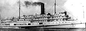
here. The causeway was built over the second main entranceway into the harbor
heavily used by the steamships of the New York Fall River Line. See this
PDF for a
comprehensive history. The
Causeway Bridge to Goat Island adds another adventure to the Newport
Harbor Walk experience. Goat Island, bought from the Narragansett Indians in
1658, has a history rich in goat raising, pirate burials, fortifications, and a
heavy history under Navy ownership. Most of the torpedos used in WWII were made
here. The causeway was built over the second main entranceway into the harbor
heavily used by the steamships of the New York Fall River Line. See this
PDF for a
comprehensive history.
Green Light on Goat Island was the key light for ships entering the Harbor from
the north. Currently in the water off Green Light and running just north of the
Newport Bridge is the possible last resting place of Captain Cook's ship the
Endeavor. Goat Island during WW2 was the site of the main U.S. Navy torpedo
manufacturing center.
Public
access on the east side of the island facing the harbor is on Goat Island
Marina with mutiple docks and a restaurant. The south end of the island is a
gated condo development. |
|
Map controls: 1. lower left corner box toggles between sattelite
or map view. 2. lower right + zooms in, - zooms out.
3. upper right
[ ] expands to full screen. 4. cursor hand allows moving the map
where you want. 5. colored symbols indicate relationship to
text.
|
How to Open Map On Smart Phone with
GPS Positioning
|
|
v.7.21.2015 copyright
WebGhosts.com and
PhotoGhosts.com Newport, RI 02840 and
Naples, FL 34102
This Newport Harbor Walk website
remains under construction. We welcome information or photos anyone would like
to share. Web Master |
|


